Measuring Urban Change in Travel Texts Using the Example of the City of Graz in the Long Nineteenth Century
Abstract Historic urban space with its formations, changes and dissolutions can be represented in various ways. This paper focuses on narrative spatial representations of the city of Graz in 19th-century guidebooks. In these texts the subjective in the individual accounts interweaves with historical reality. Two methods to reconstruct perceptions and experiences of historical spaces and spatial relationships in travel texts are presented, with the aim of making aspects of urban change measurable.
Keywords Urban history. 19th century. Maps. Travel literature. Spatial analysis.
1 Introduction
This paper is about the reconstruction of the historical urban development of Graz in Austria based on the evidence of nineteenth-century travel texts. Forms and dynamics in the perception of urban space in travel writings will be examined in this context.
A city is a complex spatio-temporal phenomenon that is widespread worldwide, but which also varies from region to region. It consists of many urban settlement elements (buildings, neighbourhoods, quarters and districts) that are intertwined and characterised by uneven phases of formation, change and dissolution. The city has long been established as a research topic in the historical sciences.1 Historical spaces are reconstructed and analysed primarily with the possibilities of a geographic information system (GIS), such as the Urban History Project of the University of Münster,2 the Stadtlexikon Stuttgart,3 the project Urban Change in Time,4 or Old Maps Online5 and Carta Historica de Barcelona and the Venice Time Machine6 or also Historical Ontology of Urban Space7 of the Polish Academy of Sciences.
This paper is based on data generated in the course of the Austrian Academy of Sciences-funded project Becoming Urban – Reconstructing the City of Graz in the Long 19th Century (2019‑21). The project is hosted and maintained at the Centre for Information Modelling (https://informationsmodellierung.uni-graz.at/en/) at the University of Graz.
1 Hans J. Teuteberg (1983) provides an overview of the beginnings of urban history research. Current research on urban history can be found in the journal Urban History, which has been published regularly since 1992. In particular, I would like to refer to the introduction “Thinking Spatially: New Horizons for Urban History” by Richard Rodger and Susanne Rau in Urban History (2020). On the use of digital methods in urban history research, see for instance Lelo, Chodějovská 2014 and the anthology by Bodenhamer, Corrigan and Harris (2010).
In contrast to the aforementioned projects, which research historical maps, atlases and place registers, the complex interaction of spaces and the change of experiential or perceptual spaces over time will be examined here exclusively on the basis of travel guidebooks. Guidebooks, which are a part of travel literature, have their own unique style and are subjectively coloured spaces of experience, but according to Neumann, it is precisely these ‘imaginative geographies’ that fulfil important functions, since narrated spaces shape notions of ‘real’ spaces, arouse expectations and aversions and offer orientation within unknown spaces (Neumann 2015, 102). They exist as an alternative to spaces that can actually be experienced and walked through (Dünne, Mahler 2015, 4). The power of the spatial imagination and experience is also put into play by the nineteenth-century novelist Gustave Flaubert in Madame Bovary:
Elle s’acheta un plan de Paris, et, du bout de son doigt, sur la carte, elle faisait des courses dans la capitale. Elle remontait les boulevards, s’arrêtant à chaque angle, entre les lignes des rues, devant les carrés blancs qui figurent les maisons. (Flaubert [1857] 1881, 62)8
8 This quote can also be found online at: http://classes.bnf.fr/essentiels/grand/ess_2629.htm.
She bought herself a map of Paris, and with the tip of her finger, on the map, she went shopping in the capital. She walked up and down the boulevards, stopping at each corner, between the lines of the streets, in front of the white squares that represent the houses.9
9 All quotes were translated with https://www.deepl.com/Translator and corrected by the Author.
When the character of Madame Bovary races a map of Paris with her finger and explores and moves through the city in her mind as she does so, Gustave Flaubert’s text passage is creating a familiar spatial situation. We transpose ourselves from physical reality to some imagined position on a line, in a grid, or a pictorial terrain (Vaughan 2010). Movement becomes the central principle, which in turn is responsible for our being able to perceive spatial constitution at all. Travel literature authors tell us about their movements, their journeys and the places they visited. What they report is indissolubly mixed with the actual object of their account and transforms into reality itself, which becomes habitable and homely, but can also decay (Ette 2020, 88). Travel writing is characterised by these dynamics. Both maps and literature are there to orientate us in the world (Ljungberg 2017).
For several decades, there has been a growing interest in space and its diverse forms of representation in the humanities.10 This paper contributes to this and focuses on the urban changes seen in Graz during the nineteenth century, examining the growth of the urban population, settlement, and urban densification. The paper continues by exploring the question of how these processes are reconstructed as structural, functional changes within individual urban settlement elements based on the narratives of guidebooks. In order to measure aspects of urban change, quantifying and analytical methods as well as methods of literary cartography are applied.
10 An overview of the context of the spatial turn and a list of selected literature can be found in Bachmann-Medick 2009, 284‑328. For basic texts on spatial research see Raumtheorie edited by Jörg Dünne (2015).
Before delving into the details of this, the next section of the paper deals with the specifics of travel writing (§ 2) in the nineteenth century. This is followed by a more detailed description of urban history in Graz (§ 3) during this period. The textual and cartographic data is then discussed (§ 4) in the context of ways in which spatial reconstruction (§ 5) is conducted.
2 Travel Writing in the Nineteenth Century
Travel literature is a form of writing that is to be regarded as historical testimony to the specific way of thinking of the author and indirectly to the mentality of his or her area of origin (Harbsmeier 1982).11 But most importantly, these narratives bear witness to the process of travel at specific points in time. They report on perceived and experienced spaces through which the authors have moved and by this means they are able to make these spaces perceptible to us (Ette 2020).
11 For a recent research overview on travel literature, see Pettinger and Youngs in The Routledge Research Companion to Travel Writing (2020), The Cambridge History of Travel Writing edited by Nandini Das and Tim Youngs (2019b), or The Routledge Companion to Travel Writing by Carl Thompson (2016). More recent approaches in research can also be found in Kuehn, Smethurst 2015, or Forsdick, Fowler, Kostova 2014.
Travel writing is about journeys that have a specific purpose. It is also about how one travels. Whether travel is on foot, in a carriage, or a train, this will have a specific impact on the itinerary and also on the perceptions of the traveller. The way the journey is reported depends on contemporary models of other writers. They address a specific reading audience which they are trying to reach and therefore take into account traditional or common writing conventions (Das, Youngs 2019b, 12‑15).
The travel narration has a long tradition but, especially from the eighteenth century onwards, the literary travelogue becomes very popular. Nigel Leask (2002, 15) links the popularity of the genre to European capitalism and colonisation. In the travel literature of the eighteenth and nineteenth centuries, the connection between travel, the idea of nation, trade and colonial expansion becomes clearly tangible. This heyday in travel literature coincides with the emergence of the modern novel, with which it has much in common. The romantic description of landscapes dominates, especially in the first decades of the nineteenth century. Whether authors describe their own country in the form of a homeland trip or travel abroad, they do so with more aesthetic appreciation for the landscape than in earlier times (Thompson 2019, 110).
In many European countries, the narrated journeys of this period describe discoveries. In exploration voyages, scientific interests can be combined with commercial interests. With increasing literacy, the number of customers in the book market multiplied, and so too did the number of authors (Das, Youngs 2019b, 2‑15). Many travel accounts were written by travellers who were not professional writers, scientists or scholars and whose descriptions were their only opportunity to publish a printed work. The model for travel reports of this time was the scientific narrative of expeditions and voyages of exploration.12
12 See Robinson 2020; Byrne 2020.
While Europeans were not alone in how they obtained information about the world, they did establish unique practices for embedding such knowledge into their cultural life and institutions. In Europe, science came to represent many things beyond data collection: a means of measurement, a mode of rhetoric, a social identity, as well as a genre of writing. (Robinson 2020, 489)
This travel literature was very well received and was also disseminated internationally and even translated into several languages. One of the most influential writers of the early nineteenth century was Alexander von Humboldt, who began publishing his travels in 1807.13
13 The travel diaries of Alexander von Humboldt are published in The Digital Humboldt Edition, version 7, 2021 (https://edition-humboldt.de/index.xql?l=de).
In addition to travelogues, the first half of the nineteenth century also saw the emergence of tourist guides, adapted to an increasing phenomenon – tourism.14 Thomas Cook, for example, began offering excursions in the 1840s, and the publishers John Murray and Karl Baedeker became market leaders with their guidebooks in the 1830s. The guidebooks offered a systematic and comprehensive overview of popular travel destinations. The personal narratives common in earlier travel reports were omitted. Alasdair Pettinger (2020) lists key features of these books. Basically, the guide should contain everything that is necessary for the traveller. Included in this is comprehensive information about locations together with maps, plans and illustrations, all of which were included in the books. In order to save space, attention was paid to concise descriptions of information. Information on opening hours and tariffs are abbreviated or given in symbols. Tables and lists are used as popular text features. Another characteristic of tourist guides is that they offer structured tours and invite the reader to follow these suggested routes.
14 Brilli (2006) gives an overview of the cultural history of travel in Italy; especially for the nineteenth century see Brilli 2018.
Finally, the guidebook tends to assume a certain kind of reader. While a travelogue represents a journey that has already taken place, the guidebook offers a fantasy that the reader is invited to act out. Baedeker rather than Murray turned out to be the model here, making fewer assumptions about the wealth and education of the person the guide is aimed at, but still targeting those middle-class readers affluent enough to afford overseas travel and able to get time off work to do so, with tastes tending towards the appreciation of nature, art and historical monuments, but not excluding sport or shopping. (Pettinger 2020, 142)
3 The Growth of Graz in the Nineteenth Century
The urban developments that took place in the long nineteenth century (1789‑1914) still shape the cityscape of Graz today. Two decrees of Emperor Joseph II in 1782 and 1784 had declared Graz an open city and abolished its fortress character. The merging of the city and the surrounding countryside could begin. Gradually, gates were removed; city ditches were filled in; even the fortress was demolished (1809).
With the disappearance of the town gate facing the river, the right bank of the river and its settlement could become part of the now open town. The gate Sacktor in Sackstraße, for example, was moved three times since its construction (fourteenth century) and disappeared in 1836, mainly because of increasing traffic (Reismann, Mittermüller 2003, 420).
The French Wars and economic stagnation contributed to the fact that the population grew only slowly in the first decades of the nineteenth century. It is estimated that Graz had about 32,000 inhabitants at the beginning of the century. A census of 1869 revealed 81,119 people (Wiesflecker 2003, 320). By the end of the period under consideration (around 1910), Graz already had more than 150,000 inhabitants (Brunner 2003a).
However as in many settlement areas, the decisive motor for the urban growth of Graz was undoubtedly the railway.15 The Mürzzuschlag-Graz connection was opened in 1844 and with it the first railway station in Graz. This gave the city a new point of reference. The area between Südbahnhof (the main railway station), Murvorstadt (the district on the right bank of the river Mur) and the core city was made accessible as early as 1844 by the construction of Annenstraße as a railway station street. The railway is to be seen in close connection with industrialisation, its track became the favoured location for factories, and bars, pubs and inns also settled close to the new station area (Dienes 2003, 368‑9). The railway not only brought a revolutionary change in transport, but also led to more tourism and improved communication possibilities. It made it easier for the people of Graz to learn about and adopt customs and ways of life in the big wide world (Dienes 2003, 371).
15 Jan Gympel dedicates his book Tempo! Berliner Verkehrsgeschichte (Tempo! Berlin Traffic History, 2015) to the phenomenon of transport and urban development. On the influence of railroads on urban growth, see also Levinson 2008 or Capuzzo 2003. For a general history of transportation, see Merki 2008.
In 1854 the Vienna-Graz line was completed, and three years later Graz was connected to the port city of Trieste. Goods could now be transported quickly and cheaply by rail:
Die Bahn ließ die Entfernungen schrumpfen. Für die Strecke Wien-Semmering-Graz hatte ein Wanderer rund vier Tage benötigt, die Postkutsche 29 Stunden. 1861 fuhren zweimal wöchentlich die Eilzüge in Wien um 6.30 Uhr ab, erreichten Graz um 12:17 Uhr und fuhren um 22.12 Uhr in Triest ein. 1884 brauchte der schnellste Zug, der Kurierzug, von Wien nach Graz 5 Stunden 5 Minuten. (Dienes 2003, 368)
The railway made distances shrink. The route Vienna-Semmering-Graz had taken a hiker about four days, the stagecoach 29 hours. In 1861, express trains departed from Vienna twice a week at 6:30 a.m., reaching Graz at 12:17 p.m. and arriving in Trieste at 10:12 p.m. In 1884 the fastest train, the courier train, took 5 hours 5 minutes from Vienna to Graz.
The fifties and sixties brought the first peak in urban development. A strong inflow of people made additional housing necessary, the expansion of the economy and public services demanded new streets and factories, eventually also new churches. The inner city became more the centre of political life, services, department stores, highly specialised retail, press and communication, banking and insurance (Dienes 1996, 153‑5). Despite the stock market crash in 1873 and bad economic times between 1879 to 1881, the population grew, and new housing had to be built (Dienes 1996, 163).
4 Data
The data for this study was created in the context of the project Becoming Urban – Reconstructing the City of Graz in the Long 19th Century.16 The aim of this interdisciplinary two-year project was to create a prototypical application for visualising historical urban development in Graz, where spaces in contemporary maps, travel accounts, and illustrations (paintings, postcards, photos) can be re-perceived and re-experienced (Bürgermeister et al. 2020).
4.1 Maps Data
Maps are graphical representations that enable a spatial understanding of things, processes or events in the world; in the project, they are used to trace landscape and structural changes. The starting point of the map material is the Franziszeische Kataster (cadastral plans) from the year 1829. All map sheets of this extensive and exact map work that refer to the Graz area were made available digitally by GIS-Steiermark17 and were used as reference map in the project. These map sheets are available online as Open Government Data (OGD) and can be integrated into a GIS in their georeferenced form. In addition to this cadastral map a second very detailed map work from the beginning of the twentieth century was georeferenced in the project. The Bundesamt für Eich- und Vermessungswesen (Federal Office of Metrology and Surveying) used the stock of around 400 individual map sheets of the so-called Feldskizzen (field sketches). These were drawn at the turn of the nineteenth and twentieth centuries. In the project they were uniformly dated 1905. On the basis of these map works, all topographic objects of each map that are relevant to the city, such as buildings, streets, squares, monuments, bridges, bodies of water, green areas and fortification walls, were transcribed as vectors in polygon forms (areas). For the map of 1829, the project team created 4,900 polygon features and for the map 1905, more than 8,600 were created. However, these figures do not allow the conclusion that the city had almost doubled in size, because the polygon data was collected in map sheets which are of different sizes.
Both datasets are available in GML (Geographic Markup Language)18 format in the long-term archive of the University of Graz:
18 The Open Geospatial Consortium develops this standard: https://www.ogc.org/standards/gml.
-
the Franziszeische Kataster
http://gams.uni-graz.at/o:beurb.fkg/GML_SOURCE;
-
the Feldskizzen
http://gams.uni-graz.at/o:beurb.feldskizzen/GML_SOURCE.
The GML file contains not only the coordinate data of the respective geo-object, but also metadata relevant for the project. An example feature looks like this in the model:
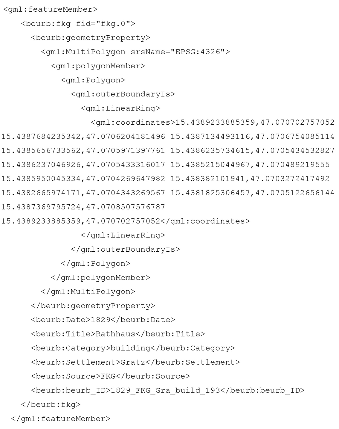
Code 1 Code snippet of the GML
The code snippet shows, in addition to the coordinates, the date of the map, the title of the geo-object (if it is labelled in the map), and the category (if it is a street, square, monument, green or water area, fortification or a building). These categories were taken over in a generalised form from the cadastral legend. Using these categories, the geo-objects can be semantically distinguished and, as you can see in the illustrations below [figs 1-2], they can be visualised accordingly. Figure 1 shows buildings in red, streets in yellow/brown colour. Figure 2 shows buildings in brown and streets in violet.

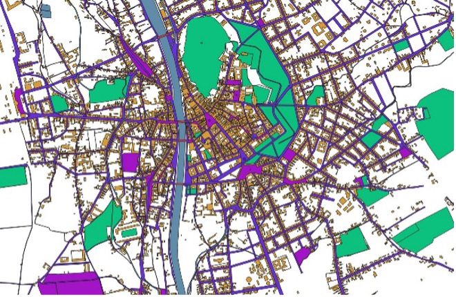
Figure 1 Author. Vector data of old Graz in 1829. 2022. Screenshot. Graz
Figure 2 Author. Vector data of Graz in 1905. 2022. Screenshot. Graz
The juxtaposition of the vector data makes the urban changes from the maps evident. Within about 70 years, the urban fabric of the city of Graz has increased enormously in size and density.
4.2 Textual Data
The short duration of the project made it necessary to limit the selection of sources to be researched. In the end, eleven travel descriptions of Graz were researched during the project period (2019‑21). The texts were all written in German and were created in different decades of the long nineteenth century (the earliest travel description dates from 1808, the latest from 1910).19
19 http://gams.uni-graz.at/context:beurb.texte. Unfortunately, no foreign language sources were included. An example of a very rich bibliography of travelogues in diverse languages on the history of Barcelona is used in the research of Susanne Rau (2014).
The first step in indexing the travel descriptions was to create a digital text, structure
it by annotation, and identify the places mentioned. All the selected works were digitised
and OCR processed. The project team then transferred those parts of the descriptions
dealing with Graz (over 600 pages in total) into TEI/XML documents.20 In the TEI model, all relevant metadata was extracted from the print and recorded
in the <teiHeader>. The logical structure in the form of headings, paragraphs, page numbers and annotations
in the texts was captured in TEI as well.
20 The Text Encoding Initiative (TEI) is a consortium which collectively develops and maintains a standard for the representation of texts in digital form (https://tei-c.org/). The guidelines are published at the following link: https://tei-c.org/release/doc/tei-p5-doc/en/html/index.html.
The main task was then to mark up all places mentioned in the texts. This was done
manually by the project team. The TEI-element <placename> was mainly used as a markup for places, while the element <geogName> was used for identifying special landscape features only, such as rivers and mountains.
Finally each identified place which could be localised was provided with a reference
to the corresponding unique identifier of the geo-object (see § 4.1).
The project team decided not to annotate retrospectives in the travel accounts, therefore only spatial information of the text that was described in the author’s presence was annotated.
The data stored in standardised formats (TEI and GML) can be processed by machines and can be reused at any time as is made public in the GAMS repository under a CC-BY-NC licence. In total, we could reference more than 4,500 objects geographically located in the observation area Graz and surroundings out of the approximately 5,650 places mentioned in all studied texts.
5 Reconstructing Urban Change
One way to reconstruct the growth and densification of settlement areas is to use a diachronic comparison of topographic maps. By this process a single perspective on the city is provided. But the question arises here of whether urban changes can also be detected in a diachronic comparison of city descriptions? What perceived spaces are revealed in these texts? How can the city be portrayed from the perspective of the authors?
To find answers to these questions, two methods of analysis are presented and their results shown. Before describing the methods and results, I want to present the selection of primary sources on the basis of which the analysis is carried out.
5.1 Selection of Primary Sources
Not all of the texts that were studied in the course of the project were used for the analysis. Five texts were selected, covering the period of the 19th century as broadly as possible. These are five guidebooks, each of which was written in different periods of the urban development of Graz. Table 1 lists the authors and the years of publication.
|
Author |
Publication date |
|
Polsterer |
1827 |
|
Schreiner |
1843 |
|
Weidmann |
1856 |
|
Cieslar |
1873 |
|
Semetkowski |
1910 |
A central criterion in the choice of these guidebooks was that the texts are similar in scope and ambition. All five aim to provide a comprehensive picture of the city and are aimed at all travellers who are interested in the city. Extensive tours of the city are provided in each of the descriptions. The authors guide their readers through the city centre, visit the Schlossberg and relate its history.21 The river Mur and the bridges that cross it also always play a role. Some of the populated city areas outside the walls and gates are referred to with the suburban title Vorstädte and are differentiated into districts in the course of the century.
21 The Schlossberg is the hill in the middle of the city on which a fortress stood until 1809.
5.1.1 Polsterer 1827
A.J. Polsterer was born in Bavaria in 1798 and spent many years in Graz as a professor of history and political science (Schuller 1980; Schlossar 1888).22 He dedicates his book, as «Hülfs- und Handbuch für Fremde und Heimische» (Guide and handbook for foreigners and locals) (Polsterer 1827, V), to the Governor of Styria Franz Graf von Hartig.23
22 See the person’s authority file entry of the German National Library: https://d-nb.info/gnd/104374365.
23 Until 1830 Franz de Paula Hartig (1789‑1865) was the Governor of Styria. Then he was appointed to the Governor of Lombardy. See the person’s integrated authority file entry of the German National Library: https://d-nb.info/gnd/116490691.
The book describes the inner city (city centre) in detail. It starts with the city gates, names the most important streets and squares and then the special buildings, churches, fountains, clocks, gardens and walks. In another chapter there is a description of the Schlossberg, which is a castle hill in the centre of the city. A fortress was located here until 1809 (Polsterer 1927, 134).24 The Vorstädte are then described in the same way (144). The infrastructure of Graz is also reported. As for external connections, an express coach is mentioned that runs three times a week to Vienna and twice to Trieste. Polsterer also informs us that, in contrast to other cities, there are still no hotels («Hôtels garnis», 282) in Graz yet.
24 You can view this page also on the project’s webpage: http://gams.uni-graz.at/o:beurb.tei.1827/sdef:TEI/get?mode=view:facs#_162.
5.1.2 Schreiner 1843
Gustav Franz Ritter von Schreiner was born in Bratislava in 1793 and died in Graz in 1872. Like Polsterer, he was a professor of political science (Wurzbach 1876, 31: 287‑91). In the preface he refers to Polsterer’s work and writes that Graz has undergone a major transformation since 1827 and that because of this the «alt Grätz» is hardly recognisable (Schreiner 1843, V). He writes the following about the developments of recent years:
So haben denn Stadt und Vorstädte im Laufe der letzten 15 Jahre in mehren ihrer Theile ein viel freundlicheres Ansehen, mehr Geräumigkeit und Regelmäßigkeit, eine größere Sicherheit und Bequemlichkeit gewonnen und den mittelalterlichen Anstrich, den sie noch vor wenigen Jahren zur Schau trugen, bereits größtentheils verloren. […] unter den Gassen zeichnen sich allein jene der Jakomini-Vorstadt dadurch aus, daß in ihrer Anlage das Bauen nach der geraden Linie befolgt worden ist, daher dieser Theil von Grätz auch den besten Eindruck auf den Fremden macht. (Schreiner 1843, 110, 111)
Thus, in the course of the last 15 years, the city and Vorstädte have gained a much friendlier, more spaciousness and regular appearance, with greater safety and comfort in many of their parts, and have already lost most of the medieval appearance they displayed only a few years ago. […] Among the alleys, only those of the Jakomini-Vorstadt are distinguished by the fact that building in a straight line has been followed in their layout, which is why this part of Grätz also makes the best impression on the stranger.
According to Schreiner, the book is primarily intended for travellers despite having over 600 pages. The first part of the book is a presentation of the geographical, statistical, climatic and natural-historical conditions of the city and its surroundings. In the second part he describes the inner city (location, ramparts, moats, city gates, squares, streets, buildings, churches and the Schlossberg) and then the Vorstädte. Schreiner has nothing to say about the transport connections to the city. He also gives no tips for inns or pubs, but names them in passing.
5.1.3 Weidmann 1856
Franz Carl Weidmann was a Viennese actor and author (1788‑1867). He published many works especially for tourists, because he was widely travelled himself (Wurzbach 1886, 53: 263‑6).
The publisher’s bookshop prompted him to write this guidebook and the term ‘tourist’ appears for the first time in connection with Graz in this book:
Es war die Aufgabe gesetzt den Fremden und Touristen, von denen unser schönes Alpenland Steiermark und dessen reizende Hauptstadt alljährlich zahlreicher besucht wird, einen zuverlässigen aber durch ein bequemes Format, auch zum Mitführen in der Tasche geeignetes Guido zu bieten, welcher auf Alles aufmerksam machen sollte, was die Stadt, die Vorstädte und die an Schönheit so ausgezeichnete Umgebung an interessanten und sehenswerthen Gegenständen umfasst. (Weidmann 1856, V)
The task was to offer the foreigners and tourists, who visit our beautiful alpine country of Styria and its charming capital city in greater numbers every year, a reliable guide, which is also suitable for carrying in the pocket due to its convenient format, and which should draw attention to everything that the city, the suburbs and the surrounding area, which is so excellent in terms of beauty, has to offer in terms of objects that are interesting and well worth seeing.
On the first 70 pages, Weidmann provides information on the history of the city, the passport, dining and coffee houses, the baths, the postal system and transport facilities. Furthermore he names important authorities, associations, charities, theatre, trade and commerce. He begins the second part of his book with walks around the inner city, the Schlossberg and the Vorstädte. At the end of the book he gives the readers a guide for stays of one or more days “um die merkwürdigsten Punkte zu sehen“ (to see the most curious points) (299).
5.1.4 Cieslar 1873
Paul Cieslar was a publisher and bookseller and he published his own guidebooks. According to his own information, his bookshop was located in the centre of the old town in Herrengasse (Cieslar 1973, 82).25 The guide book not only includes compact information about the city, but also and in particular advertising from local companies. The book begins with an advertisement of a clothing shop, followed by the title page and a detailed index of places. He presents the railway timetable [fig. 3] in a compact, extremely space-saving way; a style that became typical for the guidebooks.
25 The guidebook is provided by the Austrian National Library at http://digital.onb.ac.at/OnbViewer/viewer.faces?doc=ABO_%2BZ258329602.
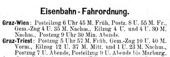
Figure 3 Author. Railway timetable. Cieslar 1873, 8. 2022. Screenshot. Graz
The description of the city starts with a chronicle of Graz and then informs travellers about passports, transport facilities, telegraph office, post office and hotels. He then mentions wine and coffee houses, delicatessen shops, cake and luxury bakers, and other retail traders. In addition to this he discusses collections of the arts and sciences, open spaces and public gardens, the Schlossberg and monuments, theatres and places of entertainment. Cieslar takes readers to notable public and private buildings, public educational institutions, hospitals and churches. At the end of the book (from page 81 onwards) a list of important addresses in Graz is provided and attached to this are over 68 pages of advertisements from Graz companies.
5.1.5 Semetkowski 1910
Walter Semetkowski lived from 1886 to 1965 and was an Austrian art historian (Brückler, Nimeth 2001, 253).26 He attempted to improve on the inherited errors of the other earlier guidebooks and he intended to inform is readers about the magnificent new buildings and the “charaktervolle alte Stadt” (old city full of character). The guidebook starts with practical advice. He recommends using the electric tram and the electric funicular for entering the city and going up the Schlossberg. He also provides information about one- and two-horse carriages and a car rental service. He names numerous hotels, restaurants and cafés, even a vegetarian dining house (Semetkowski 1910, 8). Under public institutions and businesses he also mentions bathing establishments and banks. He also lists theatres and places of entertainment as well as monuments. This is followed by a detailed overview of the location, history and characteristics of Graz, the Schlossberg and the city park. He gives tips for walking tours through the inner city and the other districts, as well as excursions in the surrounding area.
26 See the person’s integrated authority file entry of the German National Library: https://d-nb.info/gnd/12213365X.
5.2 Methods
Two methods are used as a means of perceiving urban change from the perspective of the authors: firstly a literary map is generated for each guidebook, and secondly, a functional analysis on the buildings mentioned in the guidebook will be demonstrated. The locations mentioned are essential for both methods. To the better overview, table 2 lists the guidebooks, the annotated pages, the total number of places mentioned, and the identified locations (geo-positions) found in them.
|
Guidebooks |
Transcribed pages |
Mentioned places |
Mentioned places localised |
|
Polsterer 1827 |
90 |
264 |
225 |
|
Schreiner 1843 |
172 |
440 |
398 |
|
Weidmann 1856 |
130 |
347 |
274 |
|
Cieslar 1873 |
45 |
352 |
231 |
|
Semetkowski 1910 |
85 |
547 |
434 |
What can be seen from this list is the great information content difference in the guidebooks. Measured by the numbers of pages transcribed and the places, mentioned the density of the information provided increases strongly. The way in which these texts transcend spatial changes is analysed below.
5.2.1 Literary Mapping
The method of ‘literary mapping’ is derived from literary studies and explicitly borrows conceptual, terminological and technological elements from geography and cartography. Studies on individual authors and places of action, regions, cities or genres can be understood as literary geography (Moretti, Piatti), which is the field where the method of literary mapping originated.27
27 Both have published literary atlases. Their aim is to write a spatially based history of literature, see Piatti 2009; Moretti 1999.
Critical literary mapping is about exploring the relationship between verbal and visual representations of space and place in a fully dynamic way to open up the nature of any literary work, but particularly one that contains a strongly spatial or topographical element… (Bushell 2020, 36)
Literary mapping is used here to show how the authors represent the city both verbally and visually, which places they mention and the nature of the cityscape they construct as a result. By this means we create literary maps for each guidebook. Matthew Graves defines all maps embedded in a textual document (graphically or verbally) as a “literary map”:
a graphic interface ‘where words and worlds collide’, where the author is also map-author and the reader is invited to become a map-reader in a performative way. (Graves 2005)
The literary maps are implemented as GML files containing geographic information on all referenced places of each guidebook. Screenshots of the literary maps in the GIS application (QGIS) are shown below. Each map constructs a different cityscape: green colour areas are used for all the green spaces mentioned, blue for water areas, squares are rendered light grey, dark grey is used for streets, and the buildings mentioned are coloured red.
5.2.1.1.Polsterer 1827
The visualisation [fig. 4] shows a map section of the literary map for Polsterer’s guidebook (1827).
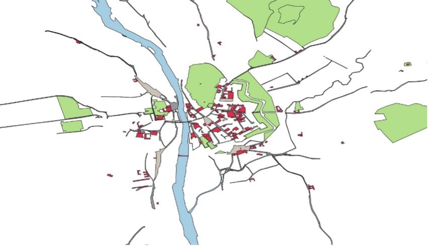
Figure 4 Author. Map section of the literary map for Polsterer’s guidebook (1827). 2022. Screenshot. Graz
5.2.1.2.Schreiner 1843
The visualisation in figure 5 shows a map section of the literary map for Schreiner’s guidebook (1843).
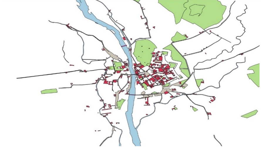
Figure 5 Author. Map section of the literary map for Schreiner’s guidebook (1843). 2022. Screenshot. Graz
5.2.1.3.Weidmann 1856
The visualisation in figure 6 shows a map section of the literary map for Weidmanns’s guidebook (1856).
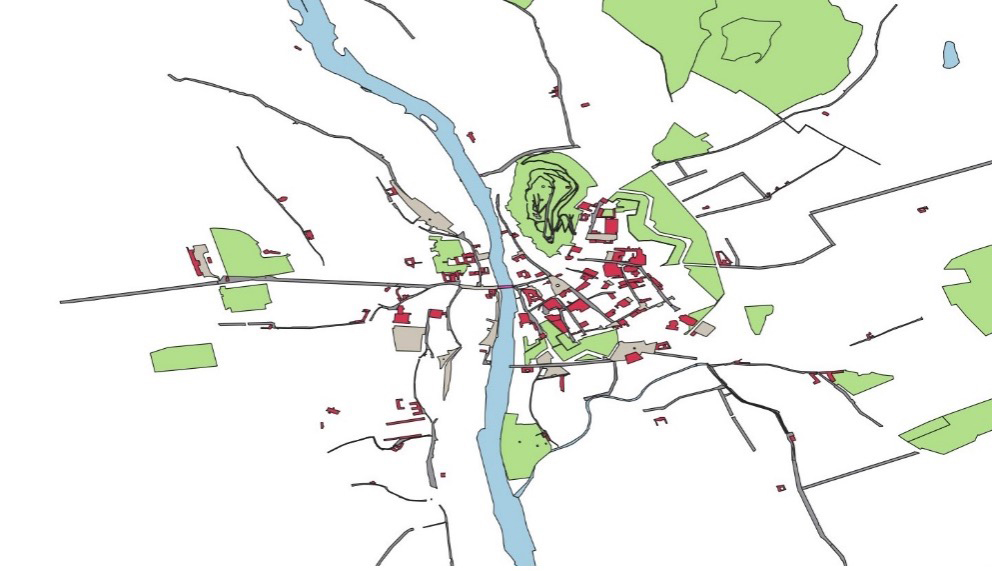
Figure 6 Author. Map section of the literary map for Weidmanns’s guidebook (1856). 2022. Screenshot. Graz
5.2.1.4.Cieslar 1873
The visualisation in figure 7 shows a map section of the literary map for Cieslar’s guidebook (1873).
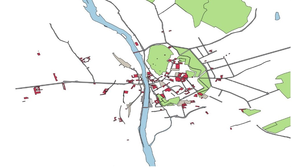
Figure 7 Author. Map section of the literary map for Weidmanns’s guidebook (1856). 2022. Screenshot. Graz
5.2.1.5.Semetkowski 1910
Figure 8 shows a map section of the literary map for Semetkowski’s guidebook (1910).
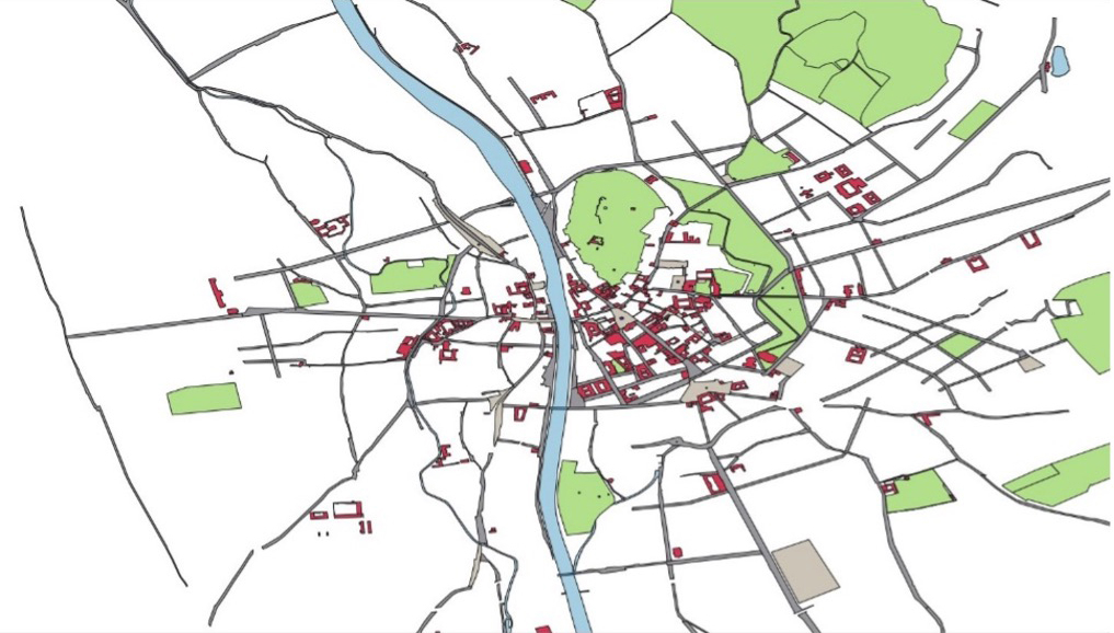
Figure 8 Author. Map section of the literary map for Semetkowski’s guidebook (1910). 2022. Screenshot. Graz
The mapping of the verbal to the visual constructs different maps, but to what extent can urban changes be uncovered? To this end, we take a closer look at the buildings. If we compare only the buildings from these literary maps, we notice the dissolution of the city form at the beginning of the nineteenth century. The walls are no longer perceived, the locations mentioned in the centre of the city become fewer and the cityscape is fragmenting in the course of the juxtaposition of these literary maps.
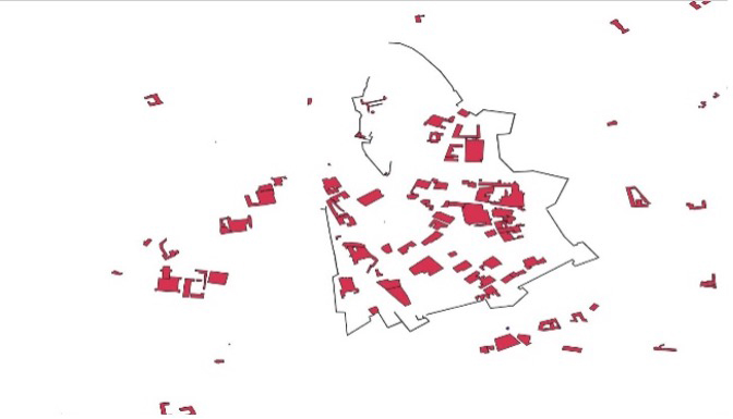
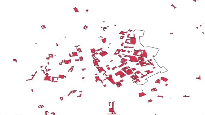
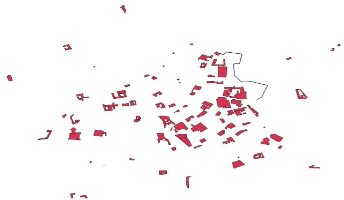
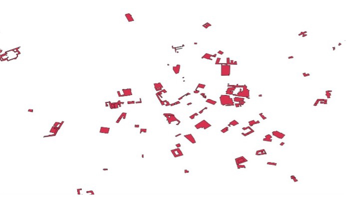
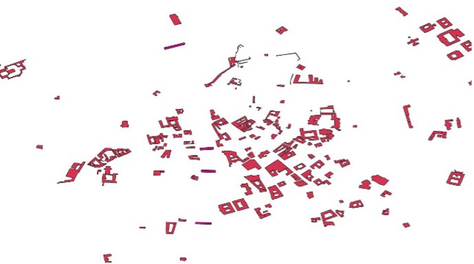
Figure 9 Author. Buildings in Polsterer (1827). 2022. Screenshot. Graz
Figure 10 Author. Buildings in Schreiner (1843). 2022. Screenshot. Graz
Figure 11 Author. Buildings in Weidmann (1856). 2022. Screenshot. Graz
Figure 12 Author. Buildings in Cieslar (1873). 2022. Screenshot. Graz
Figure 13 Author. Buildings in Semetkowski (1910). 2022. Screenshot. Graz
By contrast, a comparison of the streets and squares over the years reveals clear densification and structuring. With the exception of the descriptions in Cieslar 1873, the road network becomes more dominant in the narratives.
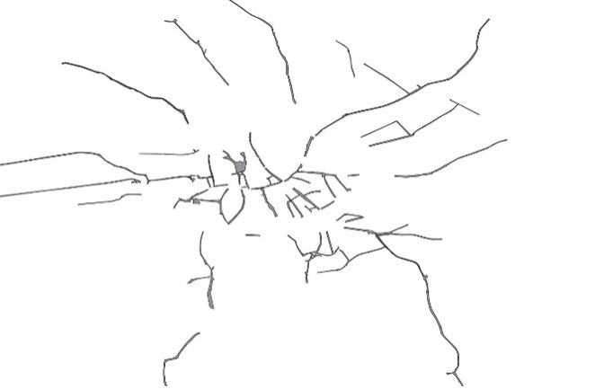
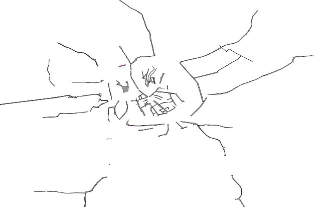
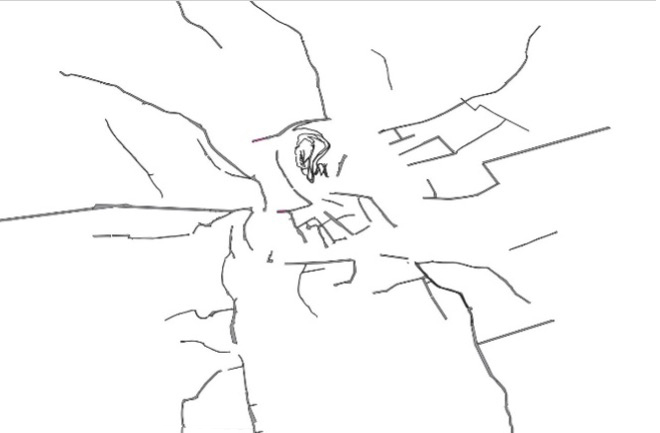
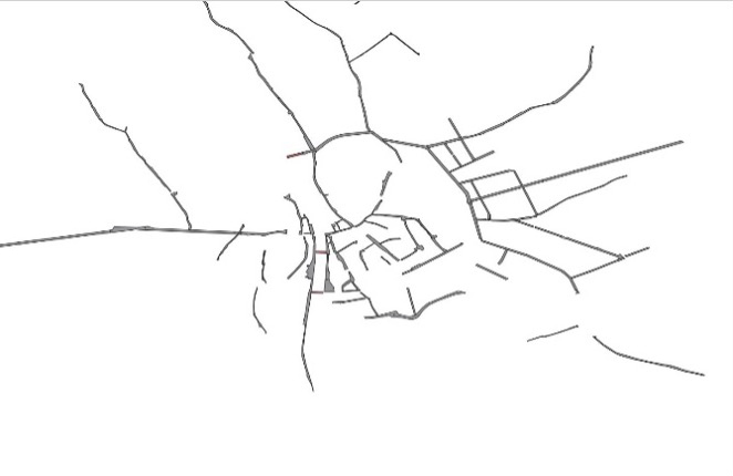
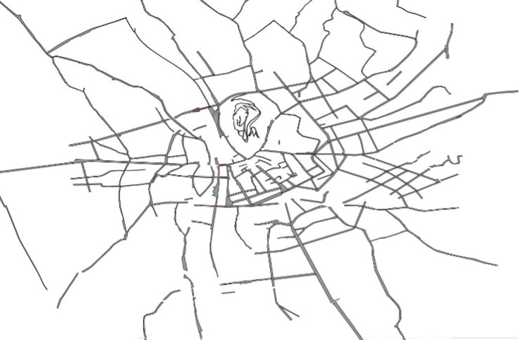
Figure 14 Author. Streets and squares in Polsterer (1827). 2022. Screenshot. Graz
Figure 15 Author. Streets and squares in Schreiner (1843). 2022. Screenshot. Graz
Figure 16 Author. Streets and squares in Weidmann (1856). 2022. Screenshot. Graz
Figure 17 Author. Streets and squares in Cieslar (1873). 2022. Screenshot. Graz
Figure 18 Author. Streets and squares in Semetkowski (1910). 2022. Screenshot. Graz
The authors move the readers around the city. They inform about the spatial relationships at specific points in time, which become recognisable through this comparison.
Finally, we can superimpose all five literary maps and thus create a cumulative map of all the place nominations in the texts. This presents us with a city that could never have existed, but it illustrates locations that were mentioned at all times in the area under consideration. In this manner, 52 locations were found, which can thus be considered as perennial favourites for tourists in Graz.28 This way of looking at the city can also be significant for the preservation of historical monuments and for the increasingly important issue of city image care. Places which are mentioned more often are coloured dark red in the following heat map:
28 Places which are mentioned in all five guidebooks: Allgemeines Krankenhaus, Alte k.k. Universität, Attems‘sche Palais, Burg, Burggasse, Bürgergasse, Convict, Domkirche, Dreifaltigkeitssäule, Franzensplatz, Franziskanerkirche, Färbergasse, Glockenturm, Grabenstraße, Griesplatz, Hauptplatz, Herrengasse, Hofgasse, Jakominiplatz, Kalvarienberg, Karmeliter-Kloster Maria-Schnee, Kloster und Spital der Barmherzigen Brüder, Landesmuseum Joanneum, Landhaus, Landhausgasse, Leechkirche, Lendplatz, Leonhardkirche, Mariensäule, Mausoleum Kaiser Ferdinands II., Minoriten zu Maria-Hilf, Mur, Murgasse, Murvorstadtplatz, Neutorgasse, Palais Saurau, Paradeis, Paulustor, Paulustorgasse, Priesterhaus, Rathaus, Raubergasse, Residenz des Bischofs, Rosenberg, Schlossberg, Stadtpfarrkirche, Stempfergasse, Stiegenkirche, Strafanstalt Karlau, Ursulinerplatz, Uhrturm, Zinzendorfgasse.
Figure 19 Author. Heat map of all places named in the selected guidebooks (1827‑1910). 2022. Screenshot. Graz
5.2.2 Spatial Function Analysis
This method is about identifying and categorising the functions and uses of all the buildings mentioned in the guidebooks. This analysis identifies further aspects of urban change in the studied texts.
For this purpose, the buildings are divided by function into 14 categories. The categories are taken from the Art & Architecture Thesaurus (AAT) published by the Getty Research Institute (2017).29 The AAT is a standardised vocabulary that contains only general terms. It is used to assign standardised values to data.30
29 Getty Research Institute (2017). Art & Architecture Thesaurus (AAT). http://www.getty.edu/research/tools/vocabularies/aat/.
30 The vocabulary was first published in 1990 and has been continuously developed since then. More information on the vocabulary and its development can be found at https://www.getty.edu/research/tools/vocabularies/aat.
The buildings mentioned in the guidebooks are categorised by concepts under the “guide
term”31 <single build works by function>.32 The following table lists the chosen concepts with assignment examples on specific
buildings in the textual sources [tab. 3]. In addition, a page link and notes from the AAT are provided for each concept. The
detailed evaluation of the results for each guidebook can be found in the Appendix.
31 “Guide term: Refers to records that serve as place savers to create a level in the hierarchy under which the AAT can collocate related concepts. Guide terms are not used for indexing or cataloguing. They are enclosed in angled brackets” ( http://www.getty.edu/research/tools/vocabularies/aat/AATCodeLookup.html?flag=RTG#record_type).
|
AAT Concepts |
Page link and notes from AAT |
Example |
|---|---|---|
|
ceremonial structures |
http://vocab.getty.edu/page/aat/300263489, structures built or used primarily or exclusively for ceremonies or related activities. |
churches |
|
commercial buildings |
http://vocab.getty.edu/page/aat/300005147, use broadly to refer to buildings associated with any aspect of the various activities and business relationships of industry and trade. |
coffee houses, banks, bookshops |
|
exhibition buildings |
http://vocab.getty.edu/page/aat/300005748, buildings built or used exclusively or primarily for exhibitions, which are organised displays of works of art or other objects of human making. |
museums, galleries |
|
Fortifications |
http://vocab.getty.edu/page/aat/300006888, general term for any works made to oppose a small number of troops against a greater. |
city walls |
|
gate structure |
http://vocab.getty.edu/page/aat/300129523, structures comprising or focused on gates or gateways. |
city gates |
|
industrial structures |
http://vocab.getty.edu/page/aat/300121918, general term that groups all structures built for the purpose of industry. |
factories |
|
institutional buildings |
http://vocab.getty.edu/page/aat/300132384, built works used by, or in support of, institutions. |
schools, hospitals |
|
Monuments |
http://vocab.getty.edu/page/aat/300006958, structures or edifices of importance or historical interest, typically erected in memory of the dead or of an important event. |
trinity columns |
|
performing arts structures |
http://vocab.getty.edu/page/aat/300121919, built works used for arts and public performance. |
theatre |
|
public accommodations |
http://vocab.getty.edu/page/aat/300164125, structures, establishments, or facilities, whether ownership is public or private, that are used by the public. |
hotels |
|
public buildings |
http://vocab.getty.edu/page/aat/300008059, buildings or groups of buildings owned and operated by a governing body, carrying out official duties, and often occupied by a governmental agency. |
city hall, post offices |
|
recreation structures |
http://vocab.getty.edu/page/aat/300122263, built works used for purpose of recreation. |
baths |
|
residential structures |
http://vocab.getty.edu/page/aat/300257729, architecture or other accommodations produced for or adapted to provide shelter and security for the basic physical functions of life for an individual, family, or clan and their dependents, human and animal. |
villas, barracks |
|
transportation structures |
http://vocab.getty.edu/page/aat/300120693, structures of any kind that serve the transportation and transport of goods and passengers. |
railroad stations |
In the guidebook by Polsterer (1827), a total of 156 buildings are mentioned in Graz. Of these buildings, 39% (61) were residential structures and 18% (28) ceremonial structures. He mentions 10 industrial buildings (6%) and 3 commercial buildings. He does not describe any public accommodation or structures for transport.
Schreiner in his book of 1843 counted 260 building mentions. The distribution of the different functional categories is similar to Polsterer’s, except for the commercial buildings, where the proportion of buildings mentioned triples (from 2% in Polster to 7% in Schreiner).
Weidmann in 1856 mentions 227 buildings. In this case, too, the proportion of commercial buildings increases threefold and coffee shops and taverns are named. Buildings used as public accommodation appear in the text for the first time. The proportion of residential buildings mentioned, on the other hand, decreases sharply.
In Cieslar’s guidebook of 1873, 197 buildings were listed. In his text, the largest number of buildings proportionately are in the ceremonial structure category, followed by commercial buildings, followed with a large margin by the category institutional buildings. The number of public accommodation buildings is unchanged from the situation reported by Weidmann.
In the last guidebook examined, that of Semetkowski in 1910, 299 buildings were found. In this text, the category commercial structure is the most strongly represented. Semetkowski names 82 buildings in this category. A sharp decline in the number of industrial buildings mentioned can be seen and he names only 2 of these.
Overall, a diachronic comparison of the results reveals that a tour of the city in the first decades of the nineteenth century is dominated by visits to representative town houses and religious buildings. The fortress walls and city gates are clearly part of the perceived cityscape and are also mentioned. Public buildings (fire station, police, post office and so on) are a fixed part of the city description until the middle of the century. The proportion of these buildings mentioned in the 1873 and 1910 descriptions then decreases sharply. In the latter, the mentions of industrial buildings also decrease. New building functions appear with the guidebook by Weidmann of 1856, these being the public accommodations and the transportation structures. Together with the simultaneous increase in commercial buildings, the analysis presents changing portraits of the city. These portraits do not allow for direct conclusions to be made about the lifestyles of the urban population in Graz during the nineteenth century, but the analysis shows that the authors emphasise different functionalities of the city, which evolve over time and demonstrate the urban as a process.
6 Conclusion
Historic urban space with its formations, changes and dissolutions can be represented in various ways. This paper focused on narrative spatial representations of the city of Graz in the 19th century in guidebooks. In these texts the subjective in the individual accounts interweaves with historical reality. Two methods were demonstrated to reconstruct perceptions and experiences of historical spaces and spatial relationships in travel text, making aspects of urban change measurable and comparable.
In contrast to successive reading of a text, the transformation of the texts into maps provides a simultaneous experience of places and their relationships to each other. The diachronic comparison enables the morphogenesis of the city (densification of the road network, enlargement of the urban space) to be traced in these accounts. Furthermore, by superimposing all maps, a cityscape was created that could be used in a particularly informative way for tourism, but also in the cultural heritage sector for preservation strategies. Significant structural and functional changes in the city descriptions in the course of the nineteenth century could be revealed by the spatial function analysis, in which the functions of the named buildings were categorised and juxtaposed. This led to the realisation that the representation of the city as a space with commercial offers, public accommodations and transport amenities does appear in the texts around mid-century and becomes much more dominant in subsequent representations.
In conclusion, the analysis of guidebooks shown here makes the urban space and its spatial relations perceivable. Facets of a historical city were reconstructed, identifying the urban as a dynamic process. All the data created in the project “Becoming Urban – Reconstructing the city of Graz in the long nineteenth century” and for this analysis is freely available and can be further used by the scientific community, driving a critical discussion about verbal and visual representation of space.
Appendix
|
Buildings by function |
Polsterer 1827 |
Schreiner 1843 |
Weidmann 1856 |
Cieslar 1873 |
Semetkowski 1910 |
|
Ceremonial structures |
28 |
36 |
25 |
41 |
41 |
|
Commercial buildings |
3 |
19 |
46 |
46 |
82 |
|
Exhibition buildings |
2 |
2 |
1 |
2 |
5 |
|
Fortifications |
1 |
3 |
1 |
2 |
0 |
|
Gate structure |
7 |
9 |
5 |
3 |
2 |
|
Industrial structures |
10 |
27 |
15 |
13 |
2 |
|
Institutional buildings |
12 |
22 |
19 |
22 |
27 |
|
Monuments |
5 |
9 |
5 |
9 |
20 |
|
Performing arts structures |
1 |
5 |
3 |
2 |
6 |
|
Public accommodations |
0 |
0 |
11 |
13 |
15 |
|
Public buildings |
13 |
21 |
22 |
5 |
9 |
|
Recreation structures |
6 |
6 |
9 |
11 |
8 |
|
Residential structures |
61 |
88 |
51 |
18 |
65 |
|
Transportation structures |
0 |
0 |
1 |
4 |
6 |
|
Other |
7 |
13 |
4 |
6 |
10 |
|
Mentioned buildings total |
156 |
260 |
227 |
197 |
299 |
Bibliography
Primary Sources
Cieslar, P. (1873). Neuester illustrirter Fremdenführer in Graz und Umgebung sowie auf Ausflügen in weitere Entfernungen, Bergtouren, Heilbäder etc. Mit dem neuesten Plane von Graz und einer Eisenbahnkarte von Steiermark. Graz: Paul Cieslar, 1-47.
Polsterer, A.J. (1827). Gräz und seine Umgebungen, historisch-topographisch-statistisch dargestellt. Mit vier lithographirten Ansichten, einem Panorama und einem Plane von Gräz. Graz: Damian, 85-175.
Schreiner, G. (1843). Grätz. Ein naturhistorisch-statistisch-topographisches Gemählde dieser Stadt und ihrer Umgebungen. Graz: F. Ferstl’schen Buchhandlung, 130-302.
Semetkowski, W. (1910). Ilustrierter Führer durch die steiermärkische Landeshauptstadt Graz. Graz: Mosers Buchhandlung, 1-78.
Weidmann, F.C. (1856). Illustrirter Fremdenführer Graz und seinen malerischen Umgebungen. Graz: Verlag der Ferstl’schen Buchhandlung, 77-210.
Secondary Sources
Bachmann-Medick, D. (2009). Cultural Turn. Neuorientierung in den Kulturwissenschaften. Reinbek bei Hamburg: Rowohlts.
Bodenhamer, D.J.; Corrigan, J.; Harris, T.M. (2010). The Spatial Humanities: GIS and the Future of Humanities Scholarship. Bloomington: Indiana University Press.
Brenner, P.J. (1990). Der Reisebericht in der deutschen Literatur: Ein Forschungsüberblick als Vorstudie zu einer Gattungsgeschichte. Tübingen: Niemeyer. Internationales Archiv für Sozialgeschichte der Literatur 2.
Brilli, A. (2006). Il viaggio in Italia: storia di una grande tradizione culturale. Bologna: il Mulino.
Brilli, A. (2018). Gli ultimi viaggiatori nell’Italia del Novecento. Bologna: il Mulino.
Brückler, T.; Nimeth, U. (2001). Personenlexikon zur Österreichischen Denkmalpflege (1850‑1990). Wien: Berger.
Brunner, M. (2003a). “Allgemeine politische und soziale Entwicklung von Graz 1850 bis 2003”. Brunner 2003b, 1: 215‑310.
Brunner, W. (Hrsg.) (2003b). Geschichte der Stadt Graz. Graz: Eigenverlag Stadt Graz.
Bundesamt für Eich- und Vermessungswesen (1905). Feldskizzen der Landeshauptstadt Graz in Steiermark. Graz: K.u.K. Militärgeographisches Institut.
Bürgermeister, M. et al. (2020). “Becoming Urban: Ein Spiel mit Räumen”. Schöch, C. (Hrsg.), DHD 2020 Spielräume: Digital Humanities zwischen Modellierung und Interpretation. Konferenzabstracts (Universität Paderborn, 02. bis 06. März 2020). Paderborn, 277‑8. https://doi.org/10.5281/zenodo.3666690.
Bushell, S. (2020). Reading and Mapping Fiction: Spatialising the Literary Text. Cambridge: Cambridge University Press.
Byrne, A. (2020). “The Scientific Traveller”. Pettinger, Youngs 2020, 17‑29.
Capuzzo, P. (2003). “Between Politics and Technology: Transport as a Factor of Mass Suburbanisation in Europe, 1890‑1939”. Divall, C.; Bond, W. (eds), Suburbanising the Masses: Public Transport and Urban Development in Historical Perspective. Aldershot: Ashgate, 23‑48.
Das, N.; Youngs, T. (eds) (2019a). The Cambridge History of Travel Writing. Cambridge: Cambridge University Press
Das, N.; Youngs, T. (2019b). “Introduction”. Das, Youngs 2019a, 1‑16.
Deutsche Nationalbibliothek (German National Library) (2021). Integrated Authority File (GND). https://gnd.network/Webs/gnd/DE/Home/home_node.html.
Dienes, G.M. (1996). “Von der Revolution zum Börsenkrach 1848‑1873”. Gesellschaft für Wirtschaftsdokumentationen (Hrsg.), Steirische Wirtschaftschronik Band 1 mit dem Wirtschaftsraum Graz. Graz: Verlag GFW, 153‑64.
Dienes, G.M. (2003). “Von der Postkutsche zur ‚rush hour‘”. Brunner 2003b, 2: 357‑90.
Dünne, J. (Hrsg.) (2015). Raumtheorie: Grundlagentexte aus Philosophie und Kulturwissenschaften. Frankfurt am Main: Suhrkamp.
Dünne, J.; Mahler, A. (2015). “Einleitung”. Dünne, J.; Mahler, A. (Hrsgg), Handbuch Literatur & Raum. Berlin; Boston: De Gruyter, 1‑11. Handbücher zur kulturwissenschaftlichen Philologie 3.
Ette, O. (2020). ReiseSchreiben. Potsdamer Vorlesungen zur Reiseliteratur. Berlin; Boston: De Gruyter.
Flaubert, G. [1857] (1881). Madame Bovary: moeurs de province. Paris: Charpentier.
Forsdick, C.; Fowler, C.; Kostova, L. (2014). Travel and Ethics: Theory and Practice. New York: Routledge.
Graves, M. (2005). “Maps and Texts: Reading Literary Maps – The Case of The Riddle of the Sands”. TRANS. Internet-Zeitschrift für Kulturwissenschaften, 16. https://www.inst.at/trans/16Nr/09_6/graves16.htm.
Gympel, J. (2015). Tempo! Berliner Verkehrsgeschichte. Berlin: Elsengold.
Harbsmeier, M. (1982). “Reisebeschreibungen als mentalitätsgeschichtliche Quelle: Überlegungen zu einer historisch-anthropologischen Untersuchung frühneuzeitlicher deutscher Reiselitertur”. Maczak, A.; Teuteberg, H.J. (Hrsgg), Reiseberichte als Quellen europäischer Kulturgeschichte. Aufgaben und Möglichkeiten der historischen Reiseforschung. Wolfenbüttel: Heckner, 1‑32.
Jäger, F. (2003). “Wirtschaftsgeschichte 1800‑2000”. Brunner 2003b, 2: 159‑238.
Kuehn, J.; Smethurst, P. (2015). New Directions in Travel Writing Studies. Basingstoke: Palgrave Macmillan.
Leask, N. (2002). Curiosity and the Aesthetics of Travel Writing, 1770‑1840: ‘From an Antique Land’. Oxford: University Press.
Lelo, K.; Chodějovská, E. (2014). Digital Methods for Urban History. Roma: Croma.
Levinson, D. (2008). “The Orderliness Hypothesis. The Correlation of Rail and Housing Development in London.” The Journal of Transport History, 29(1), 98‑114. https://doi.org/10.7227/TJTH.29.1.8.
Ljungberg, C. (2017). “Reading as Mapping”. Tally, R.T. (ed.), The Routledge Handbook of Literature and Space. 1st ed. Abingdon; New York: Routledge, 95‑105. https://doi.org/10.4324/9781315745978.
Merki, C. (2008). Verkehrsgeschichte und Mobilität. Stuttgart: Ulmer.
Moretti, F. (1999). Atlas des europäischen Romans: wo die Literatur spielte. Köln: DuMont.
Neumann, B. (2015). “Raum und Erzählung”. Dünne, J.; Mahler, A. (Hrsgg), The Routledge Handbook of Literature and Space. Berlin; Boston: De Gruyter, 96‑104. Handbücher zur kulturwissenschaftlichen Philologie 3.
Pettinger, A. (2020). “Guidance and Advice”. Pettinger, Youngs 2020, 139‑52.
Pettinger, A.; Youngs, T. (eds) (2020). The Routledge Research Companion to Travel Writing. London; New York: Routledge.
Piatti, B. (2009). Die Geographie der Literatur. Schauplätze, Handlungsräume, Raumphantasien. Göttingen: Wallstein.
Rau, S. (2014). “Writing Spatial Relations and Dynamics: Movements in Urban Space (Barcelona, 16th-19th Century)”. Rau, S.; Schönherr, E. (eds), Mapping Spatial Relations, Their Perceptions and Dynamics. The City Today and in the Past. Cham; Heidelberg: Springer, 139‑56.
Rau, S. (2017). Räume. Frankfurt; New York: Campus. Historische Einführungen 14.
Reismann, B.; Mittermüller, F. (2003). Geschichte der Stadt Graz: Stadtlexikon. Graz: Eigenverlag der Stadt Graz.
Robinson, M.F. (2020). “Science Journey”. Pettinger, Youngs 2020, 488‑503.
Rodger, R.; Rau, S. (2020). “Thinking Spatially: New Horizons for Urban History”. Urban History, 47, 372‑83. http://doi.org/10.1017/S0963926820000218.
Schlossar, A. (1888). “Polsterer, Adalbert Johann”. Allgemeine Deutsche Biographie, 26, 400‑1. https://www.deutsche-biographie.de/pnd104374365.html#adbcontent.
Schuller, A. (1980). “Polsterer, Adalbert Johann (1798‑1839), Historiker, Journalist und Schriftsteller”. ÖBL 1815‑1950, vol. 8, 187. www.biographien.ac.at/oebl/oebl_P/Polsterer_Adalbert-Johann_1798_1839.xml?frames=yes.
Teuteberg, H.J. (1983). “Historische Aspekte der Urbansierung: Forschungsstand und Probleme”. Teuteberg, H.J. (Hrsg.), Urbanisierung Im 19. Und 20. Jahrhundert: Historische Und Geographische Aspekte. Köln; Wien: Böhlau, 2‑34.
Thompson, C. (2016). The Routledge Companion to Travel Writing. London: Routledge.
Thompson, C. (2019). “Nineteenth-Century Travel Writing”. Das, Youngs 2019a, 108‑24.
Urban History (1992-). Cambridge: Cambridge University Press.
Vaughan L. (2010). “Mapping the Imagined”. Kriz, K.; Cartwright, W.; Hurni, L. (eds), Mapping Different Geographies. Heidelberg; Dordrecht; London; New York: Springer, 93‑102.
Wiesflecker, P. (2003). “Bevölkerungsentwicklung”. Brunner 2003b, 1: 311‑34.
Wurzbach, C. (1876). Biographisches Lexikon des Kaisertums Österreich – Einunddreißigster Teil – Schnabel – Schröter. Graz: Universitätsbibliothek Graz. http://www.literature.at/alo?objid=12540
Wurzbach, C. (1886). Biographisches Lexikon des Kaisertum Österreichs – Dreiundfünfzigster Teil – Wallnöfer – Weigelsperg. Graz: Universitätsbibliothek Graz. http://www.literature.at/viewer.alo?objid=11712.